How Cutting‑Edge Technology Is Improving SMR’s Ability to Save Lives
Search and rescue in the Pacific Northwest is shaped by the landscape itself. Thick forests limit visibility, rugged mountains slow travel, and weather can shift from calm to hazardous in minutes. These conditions demand speed, adaptability, and clear coordination—qualities that become harder to maintain the farther teams move from roads and cell coverage.
That’s why Seattle Mountain Rescue (SMR) is investing in technologies that help us overcome these natural barriers. From drones that search large areas quickly, to satellite tools that keep teams connected, to e‑mountain bikes and exoskeletons that improve mobility, to AI systems that help manage complex missions. Each innovation strengthens our ability to respond when someone needs help. These tools are becoming essential parts of modern SAR operations, and we’re actively evaluating and adopting them as they become available.
Drones
Drones now play three primary roles in search and rescue: search, support, and awareness.
Search
Modern drones can autonomously fly complex grid patterns over mountainous terrain while using thermal imaging, optical zoom, and AI-assisted detection.
What once took hours—or even days—can now take minutes. Subtle movement, color anomalies, or heat signatures that might be missed by the human eye can be identified quickly from the air.
Support

Drone with Rescue Litter
Drones can deliver critical equipment to precise locations in a fraction of the time it would take a ground team. Smaller drones can carry essential items such as radios, flashlights, or medical supplies like EpiPens and AEDs.
Larger platforms are available that can transport significantly heavier gear—such as ropes, litters, or advanced medical kits—directly to a scene. As a volunteer nonprofit organization, acquiring this type of equipment remains a challenge, but it represents a major opportunity to improve response capability.
Awareness
Drones provide real-time video to teams in the field and personnel at base. This improves decision-making and safety.
Examples include:
- Assessing rockfall or avalanche risk above a rescue scene
- Lighting a medical scene or difficult terrain during night operations
- Providing a broader operational view for coordination
One area of drone research is swarming or having multiple drones working together to dramatically reduce search time – cutting hours down to minutes.
At the same time, AI-powered image and video analysis is rapidly improving. A great example being Eagle Eyes Search. Drones are increasingly able to detect subjects in real time – oftentimes identifying things a human pilot would miss, and broadcast real-time mission updates to all of the rescue teams.
Satellite Connectivity
Reliable communication is critical in the environments where we operate.
With satellite connectivity, Seattle Mountain Rescue can maintain data and communication links even in remote areas with no cell coverage. This enables:
- Live video consultation with medical personnel
- Real-time updates between field teams and Base
- Continuous data sharing during extended missions
- Portable Starlink connection for wifi connectivity in remote locations
Many cell phones now support satellite communication allowing position updates for rescue members in the back country, and messaging when outside traditional cell coverage.
Map Sharing & Real‑Time Coordination

SarTopo
Modern search and rescue depends on accurate, shared mapping—especially in the complex terrain of the Pacific Northwest. SMR uses Caltopo as our primary mapping platform to keep teams aligned, informed, and safe throughout a mission. It allows us to mark command post locations, track subjects, and visualize terrain in ways that support faster, clearer decision‑making.
One of the most powerful capabilities we now rely on is the ability for 911 to capture a subject’s cell‑phone coordinates in seconds. Once those coordinates are received, they can be dropped directly onto our SarTopo mission map and shared instantly with every team in the field. This gives rescuers a precise point—often the difference between hours of searching and a rapid, targeted response.
SarTopo also enables real‑time tracking of ground teams, helicopters, and drones, giving mission leaders a live operational picture as conditions evolve. When new information comes in, every rescuer sees the same updated map, ensuring that teams converge quickly and efficiently. This shared mapping environment has become one of the most important tools in modern SAR operations.
E-Bikes
 E‑mountain bikes are becoming an increasingly valuable mobility tool across modern SAR operations, giving teams new ways to move quickly and extend their reach. They allow rescuers to cover large distances quickly, transport gear more efficiently, and access non‑technical terrain far faster than traveling on foot.
They’re especially effective on trail systems and in urban searches where speed and mobility directly improve response times. As battery technology and cargo‑carrying options continue to advance, e‑mountain bikes are opening new possibilities for rapid deployment and early‑stage search coverage.
Thanks to the partnership with The Line Bike Experience, SMR was generously donated an initial fleet of unit bikes to make available for member use.
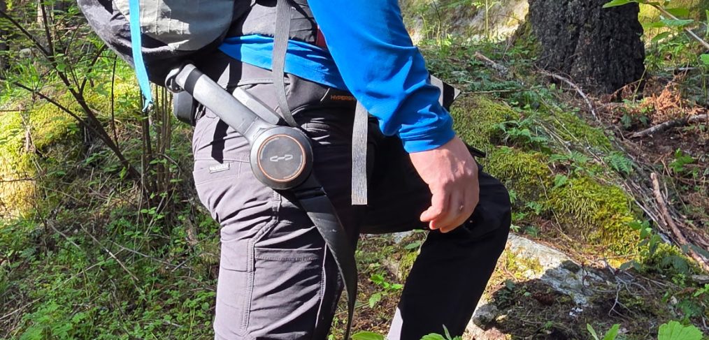
Exoskeletons
Powered exoskeletons are an emerging technology with real potential for search and rescue. These systems use lightweight power‑assist mechanisms and AI‑driven motion control to help rescuers move more efficiently on foot, carry heavier loads, and reduce fatigue on long approaches.
SMR is currently partnering with Hypershell to evaluate the Hypershell X exoskeleton device to understand how it performs in steep, brushy, or snowy terrain where other tools—like e‑mountain bikes—can’t go. Initial field use is giving us a clearer picture of where this technology can fit into our overall response toolkit.
AI‑Driven Mission Support
Search and rescue operations are complex, involving multiple teams, tools, and agencies working simultaneously.
 AI-driven software we’re currently working on (LOLA) is aimed to help us improve coordination and efficiency by:
- Processing initial dispatch information
- Assisting with mission planning
- Managing operational complexity in real time
As these technologies evolve, we’re evaluating how they can help teams stay ahead of changing conditions and operate with greater clarity in the field. Our current agent project is called LOLA, which will help us improve communications with the sheriffs dept when a mission begins.
A Volunteer Team Powered by Technology
Seattle Mountain Rescue is a 100% volunteer organization. Every mission is supported by individuals who dedicate their time, training, and expertise to helping others in difficult situations.
Technology is not a replacement for that commitment—it’s a force multiplier.
It allows us to respond faster, operate more safely, and make better decisions in the field. As these tools continue to evolve, they will play an even greater role in helping us carry out our mission.
SMR now offers several tax-smart giving options. Consider a gift of stocks, donor advised funds (DAFs) or qualified charitable distributions (QCDs). If you’re interested in supporting Seattle Mountain Rescue, your contribution would help bring these and other tools into the field—and ultimately, helps us save lives – www.seattlemountainrescue.org/donate


 Some heroes wear helmets. Some carry ropes.


